Geo-Integrity Atmospherics
Geo-Integrity-Atmospherics
A Mid Hudson Valley Drone and Videography Company


Geo-Integrity Atmospherics is a professional uncrewed aerial services provider specializing in high-precision data collection, raw data export, and technical reporting. Based locally, we possess a deep understanding of our regional community, its unique landscapes, and local conservation and agricultural priorities.
We are licensed, fully commercially insured remote pilots with extensive field experience handling complex, GPS-denied, and highly sensitive flight conditions across environmental, structural, and media sectors. We generate clean raw data, actionable field reports, and high-end visual media based on three core areas of established operational experience:
1. Special Architectural & Building Site Surveys
-
Field Operations: Conducting advanced aerial site surveys, including complex interior drone photogrammetry of historic structures, vaulted ceilings, and church dome interiors in New York City, as well as exterior data collection to support planning processes in conjunction with engineering, surveying, and municipal professionals.
-
Data & Reporting: Delivering high-resolution raw imagery, interior structural documentation, and topographic overviews used directly for preservation, site development, compliance, and collaborative project planning.
2. Environmental Mapping & Conservation Science
-
Field Operations: Precision ecological and agricultural mapping for prominent regional land trusts and environmental conservation organizations.
-
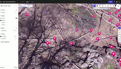
Data & Reporting: Utilizing state-of-the-art multispectral hardware paired with high-precision Bluetooth GPS receivers to achieve sub-meter geographic accuracy. We export raw GIS files for direct integration into ArcGIS and build multi-year comparative tracking maps to monitor plant health, crop conditions, and invasive species distribution.
3. High-End Creative Media for Filmmakers
-
Field Operations: Precision aerial filming and post-production support for professional filmmakers working on high-end, national historical documentaries, including projects aired on PBS.
-
Creative Deliverables: Delivering broadcast-quality raw cinematic video data, production stills, and video editing sequences. We combine technical flight control with a strong creative eye for composition and visual framing to meet the strict narrative and technical standards required by elite documentary filmmakers.
Core Operations & Deliverables
-
Local Expertise: Grounded in the local community with firsthand knowledge of regional terrain, environmental factors, and community stakeholders.
-
Creative & Technical Versatility: Equal proficiency in generating strict, raw scientific and structural datasets—both interior and exterior—and capturing high-end cinematic imagery for documentary filmmakers.
-
Compliance & Safety: FAA Part 107 certified, fully insured for commercial operations, and experienced in logging technical flight parameters in highly complex environments.
-
Data Outputs: Raw data file exports (ArcGIS compatible), high-resolution interior/exterior structural imagery, multispectral comparative tracking maps, high-definition cinematic video files, and detailed technical field reports.